The Loop
“The Loop serves as a fantastic car-free multi-use recreational facility, and it’s also a legitimate transportation system that offers great commuting opportunities by connecting nearly every jurisdiction in Pima County.” – Andy Dinauer
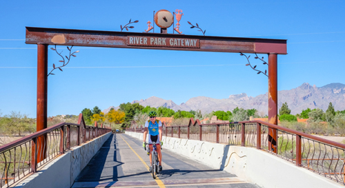
Bridges, like at River Park Gateway, cross washes and display arts,
while providing unparalleled vistas.
photo: Leigh Spigelman
On foot, two-wheels, skates, stroller or horseback, you will find amazing place-making, one mile at a time, along this treasured haunt. The Loop entertains and invigorates all, every day, and it’s one helluva meander.
The city seemingly drops behind when you traverse this interconnection of blacktop, soft sand and gravel paths that hug Pima County’s various river-park systems. While the exact mileage of the linked, Loop-ed trails is a moving target – The main Loop (along the Rillito, Pantano, Julian and Santa Cruz River washes) is approximately 55 miles. With its “fingers” extending up Cañada del Oro wash to Oro Valley, and the Santa Cruz extensions north to Marana and south to San Xavier – this Loop system is more like 130 miles of connected trails.
Engineer Andy Dinauer is the Pima County regional flood control district Division Manager responsible for The Loop projects. His life’s mission is wrapped up in the vision for keeping The Loop accessible…but you’ll need to hustle to keep up with Dinauer, who cycles 120 miles on The Loop each weekend for fun and another 125 miles during each week as part of his daily bike commute.
“The Loop serves as a fantastic car-free multi-use recreational facility, and it’s also a legitimate transportation system that offers great commuting opportunities by connecting nearly every jurisdiction in Pima County,” says Dinauer, who began working on regional watercourse bank stabilization projects in the mid-1980s and has been active in the creation of new Loop segments for the last five years.
Michael McKisson, publisher and editor of the popular TucsonVelo.com cyclist info and advocacy network, agrees that The Loop makes it easier for people around the city to enjoy a car-free place to recreate and transport. “I see The Loop as a gateway,” comments McKisson, who lives along the south bank of the Rillito River. “Many cyclists start on The Loop and graduate to other types of riding including using a bike for transportation.
“When we moved in it was dirt and cyclists were banned, but now it’s open to cyclists and my daughter learned to ride her bike on it,” he adds.
Fueled by Floods
According to Dinauer, Tucson’s river park system, and ultimately The Loop, started as a result of the 1983 floods. Following this disaster, Pima County undertook a tremendous effort to stabilize the banks of the Rillito, Pantano and Santa Cruz Rivers. Included with many miles of bank stabilization installation was the need for a continuous maintenance access route along the top of the channel banks.
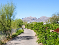
Shaded paths offer green respite and gateways to adjoining neighborhoods.
photo: Leigh Spigelman
“Over time these long linear maintenance access routes evolved from simple dirt trails to the fully improved riverpark segments we see today,” he explains, crediting the County Administrator along with the Pima County Board of Supervisors, the Pima County Flood Control District and Pima County Natural Resources Parks and Recreation with crafting the Loop and riverpark vision that has been systematically implemented over the last 25 years.
“Citizens of every demographic can enjoy it,” adds Michael Woodward, founder of Michael Recruits talent recruitment agency who recently moved here from Seattle. “Because it covers so much of Tucson, The Loop is a great socioeconomic connector and sets Tucson apart from other cities.”
Refresh and Ramble
The Loop system incorporates many rest stops as well as places to see the artistry, and Pima County’s trail system map, updated in January, outlines the amenities as well as the paths.
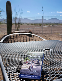
A table outside of Tucson’s Loop Bicycle Shop, where they extends repairs and special amenities off the Santa Cruz sector.
photo: Leigh Spigelman
One entrepreneurial must-see spot sits along the Santa Cruz route, just north of West El Camino Del Cerro. Tucson’s Loop Bicycle Shop, 3201 W. Diamond St., is an oasis co-founded by Michael Wilkinson along with Sonoran Landscaping owner Robert McLoy. Operating since 2012 out of a metal storage unit just off The Loop along the back side of the Sonoran rock and gravel biz – this respite offers grand vistas as well as bike mechanics, gear, coffee and cold drinks, energy snacks, various local products and very clean restrooms. On weekends and select weekdays, there’s also entertainment and more eats, including Tommy’s On the Road café/food truck, which cooks up breakfast, subs and other dishes.
Dotting The Loop are other interesting rest spots and parking areas. For example, on the south bank of the Rillito just east of Alvernon Way, one station offers crafted flagstone lounge furniture. Near Sweetwater Wetlands, recent path improvements on the east bank of the Santa Cruz between Grant and El Camino Del Cerro also offer a rest area with leaf-themed bike racks, a wildlife themed bench and a decorative trash can.
While each Loop segment has its distinct quality, the granddaddy of them all is the promenade along Rillito. Also the site of the most recent Loop improvements, the Rillito’s north bank path from Campbell to La Cholla (4.5 miles) was just widened and resurfaced. Dinauer notes that this section was the oldest (late 1980s vintage), narrowest and most congested section, and it was long overdue for its facelift, completed in March.
Path Picks
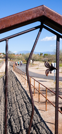
The Loop extends to the washes, with entries for close-to-nature and equestrian enjoyment.
photo: Leigh Spigelman
With The Loop being a center of gravity for so many, a crossover appeal has emerged, as walkers mix it up with cyclists, who hum alongside joggers, stroller-pushers, dog walkers and septuagenarians. There are unique vistas, eclectic artwork, parks and even historical buildings collected along the natural necklace of trails. There’s the Garden of Gethsemane and the artistic Luis G. Gutierrez Bridge/Cushing Street bridge in the southwest, the Fantasy Island Mountain Bike trails park in the southeast (note: sections here still planned or under construction), and access to Binghampton Rural Historic District to the north. Freestyle BMX riders, sports enthusiasts, hill climbers and soccer players can check the map for additional unique offerings all accessible via The Loop.
Everyone has their favorite route. Dinauer tends to frequent the Santa Cruz and Rillito segments. “During the winter months I probably spend more time on the Santa Cruz because of the abundance of sunshine while in the heat of the summer the Rillito offers some very shady corridors on its many tree-lined sections.”
Velo’s McKisson pinpoints another Rillito spot as his favorite. “There is a section of The Loop on the north side between La Cholla and La Cañada where the trees make a kind of tunnel.”
For Woodward, his favorite section starts at Swan and River, with its parking area and small park, which allows him to travel across the washes in extended directions: “I love the bridges and the vistas they provide – heading north from Swan and River you can go off the tar path and walk the trail, experiencing the wildlife. I also love the River Park Gateway Bridge (just east of Rillito Raceway Park) that lets you cross over the wash.”
Future Talk
Ongoing are Pima County’s plans for interactive mobile mapping applications as well as completion of missing links on The Loop. Two hoped-for 2015 improvements skirt the Pantano Wash (from Craycroft Road to Tanque Verde Road) and the Harrison Greenway (which links the Pantano and Julian Washes).
Dinauer also mentions the Paseo de las Iglesias Phase I (a Santa Cruz river bank protection, ecosystem restoration and creation of a seven-mile linear parkway, along Ajo Way and Silverlake Road), as an active Loop project, with others in the planning stages.
“I think The Loop’s success should tell government officials that people really want a safe and separated bike infrastructure, not just looping around the region, but right though the middle of it too,” observes McKisson. “I’d also like to see more linear parks within the city limits that connect to the outer loop.”
Woodward adds his hopes for more access points, even a Streetcar connection. “There are whole sections off River and Sabino that can’t be accessed unless you live in a development that backs up to the path,” he says. “Another idea would be to have dedicated paths from The Loop connecting to spots where you can catch the Streetcar, really creating a car-alternate route for commuters.”
So many possibilities for The Loop to fulfill Tucson’s sustainability vision, and connect community to its soul. The adage asks: Is it the journey or the destination? When you explore The Loop’s many dimensions, you discover it may be a little of both.
More information is available at Webcms.Pima.gov/Government/The_Loop/.
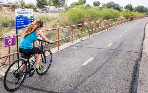
The Rillito is the oldest stretch, with recent renovations widening
and resurfacing 4.5 miles of this trail way.
photo: Leigh Spigelman
Category: Community, Living, Nature, RECREATION


